
Utah Rocks
Geologically Speaking!
After leaving the Four Corners area of Colorado, we headed northwest to Moab, Utah – the heart of red rock country. Moab is centrally located to Arches National Park, Canyonlands National Park, and Dead Horse Point State Park in the eastern central area of Utah. This stop was by far the hottest stop on our trip to date with temperatures hovering around 105 degrees each day.
Arches National Park provided us with incredible views during sunrise and sunset with the low sun painting beautiful red and orange hues across the arch formations. This national park is a photographer’s dream, but the dry dusty air and haze from a socked-in high pressure area presented many challenges to our desire for miles of clear visibility. One evening Anna and I hiked to the windows area of Arches, where we climbed and sat inside the north window to photograph the sunset toward balanced rock to the west.
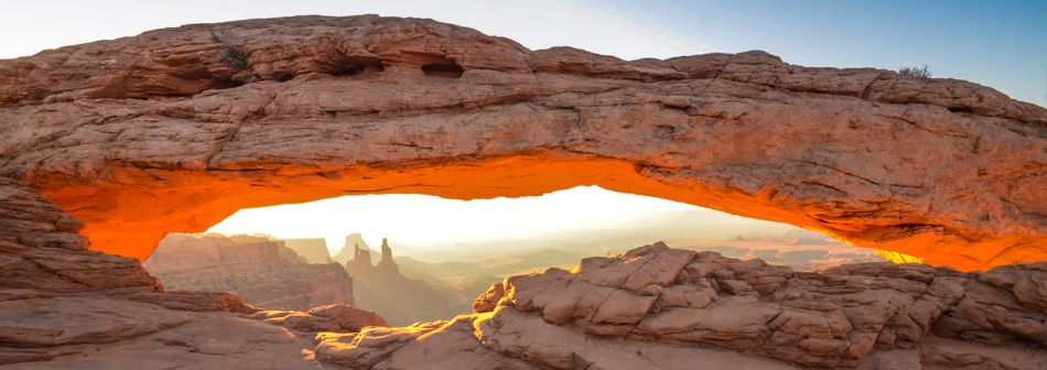
I dragged Anna out of bed the next morning at four o’clock so we could photograph the sun rise behind the Mesa Arch at Canyonlands National Park. It took a while to drive to the park, and hike to the arch, but as Anna stood witnessing the beauty of the sun reflecting off the bottom of the Arch, she said she wouldn’t have missed the breathtaking view for anything. One of the photos from that morning is at the top of this blog.
The next day, we and our friends (Curt and Cathy) rented a couple of Jeeps built for off-road travel. We drove the Jeeps up and down mountain trails, and through the canyon lands and Dead Horse Point State Park past the cliff that Thelma and Louise jumped from in the movie by the same name. Many people told us the best way to see the canyon lands was off road in the back country – and they were right.
The day before we left Moab we were able to visit with FMCA and Clemson University friends Steve and Judy from South Carolina, who just happened to arrive the day before we were scheduled to leave. What a small world we live in. We really enjoyed this stop, but it was time to move on, and we headed west to Torrey, Utah and the Capitol Reef National Park.
Upon arriving at Capitol Reef we came to a rather abrupt stop in the road to avoid hitting several mountain goats running in front of our motorhome. Capitol Reef seems to be about the rocks, but it is really about the water. It is a strange, beautiful landscape of multi-hued rock layers with formations of the “Waterpocket Fold” and Cathedral Valley. Massive domes, soaring spires, and stark monoliths cover the landscape. Here we visited the Fruita Historic District and the Gifford House for a look at how the early settlers lived.
On our last day in the area, Anna and I drove south along Scenic Byway 12 to the towns of Boulder and Escalante through the Grand Staircase Escalante National Monument. Breathtaking and magnificent are the first two adjectives that come to mind in an attempt to describe the scenery along this drive. We drove to summits of 9,600 and 10,400 feet with descent grades of 8-14 percent with an eye out for mule deer and cows in the road. Yes, cows. There are many areas in Utah with open ranges. What a drive!
We are on a summer schedule, so the time has come to moo-ve on. As we say goodbye to Utah, we are setting our sites to the east. We are now traveling toward the northern areas of Colorado. More will follow on the next leg of our summer 2013 journey.
Click here to view additional photos related to this blog.
As always, we hope to see you down the road!
Deprecated: Function get_magic_quotes_gpc() is deprecated in /hermes/walnacweb07/walnacweb07am/b1892/moo.fanningoutcom/wp-content/themes/wanderland/framework/lib/mkdf.functions.php on line 208